Synopsis:
There will be no change in our stretch of Spring-like readings through Friday. Temperatures will be fifteen to twenty five degrees above the average high of the lower 40s. An April feel will continue as a strong Southwest flow continues around a Western Atlantic high.
A storm will develop over the Southern plains this morning. Any morning sun will give way to afternoon clouds. A warm front will push through our region during the afternoon with showers or even a quick period of rain. It’ll be balmy.
The low will move to Montreal, Canada by Friday morning. A cold front will sweep through the region at this time with another period of rain. Morning highs will be Spring-like, then drop during the day.
Saturday we’ll finally experience seasonable readings with highs in the lower 40s as cooler high pressure takes hold. The chill won’t last as the high move offshore and the mild return flow greet us for the second half of the weekend. Both days will feature mainly sunny skies.
On Presidents’ Day temperatures will once again reach early Spring readings ahead of an approaching cold front.
Stay tuned.
Keep it here for a no hype, no nonsense forecast.
Thursday:
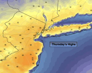
Sun will give way to clouds. Warm. Scattered showers or a quick period of rain. Highs in the mid 60s. Cooler over Eastern areas. West to South winds at 5-10mph.
Tonight:
Mostly cloudy. A spotty shower possible. Very mild. Lows in the mid 50s along the urban corridor, the 40s inland. These readings are ten to fifteen degrees above the average high for the date! Amazing. Southeast toSouthwest winds at 5-10mph.
Friday:
Morning rain to mid to late afternoon sun. Warm to start. Temps will drop during the day. AM highs in the lower 60s falling to the upper 40s by late day.
Saturday:
Sunny. Seasonable. High in the lower 40s.
Sunday:
Partly sunny, mild. High around 50º.
Presidents’ Day:
Partly sunny, mild. High in the mid 50s.