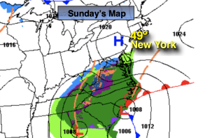
Synopsis:
Low pressure will develop in the Carolina’s. Any morning sun North will give way to increasing afternoon clouds in all areas for Super Bowl Sunday.
The storm will move up and off the coast tonight into Monday morning. Coastal rain is in the forecast. Inland it will remain dry. The rain will be out of the region by Monday mid morning out East. Clouds will give way to mainly sunny skies and yep, mild readings will stick around.
No change in our stretch of mild conditions for Tuesday through Thursday. Readings will be ten to twenty degrees above the average high. An April feel will greet us once again as a strong Southwest flow develops around a Western Atlantic high.
The jet stream, the river of air that guides our weather systems has predominately been out of the Pacific-a mild result. The polar jet that frequently visits our region during the Winter has been M.I.A.
Stay tuned.
Keep it here for a no hype, no nonsense forecast.
Sunday:
Any sun North giving way to increasing and thickening afternoon clouds in all areas. Highs in the upper 40s to around 50º. Southwest to East winds at 5mph.
Tonight:
Coastal rain in spots. Cloudy elsewhere. Lows in the upper 30s along the urban corridor, the 20s inland. Northeast to North winds at 5-10mph.
Monday:
Any early morning clouds and areas of rain at the coast, otherwise becoming mostly sunny. Highs around 50º.
Tuesday:
Sunny and mild. Highs in the lower 50s.
Wednesday:
Partly sunny. Very mild. Highs in the upper 50s to lower 60s .
Thursday:
Partly sunny. Warm. Chance of an isolates shower. Highs in the lower 60s