Synopsis:
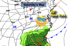
High pressure will move in for Saturday. Temperatures will be tolerable under a sunny sky. Readings will be around five degrees above the average high of 41º.
On Sunday, low pressure will develop in the Carolina’s. Morning sun will give way to increasing afternoon clouds for Super Bowl Sunday.
The storm will move up and off the coast Sunday night into Monday morning. Coastal rain is in the forecast. How far inland the rain pushes is a question that needs to be answered. Whatever happens with the storm’s specific track, the precipitation threat will be out of the region by Monday late morning. Clouds will give way to mainly sunny skies by afternoon and yep, mild readings will stick around.
No change in our stretch of mild conditions for Tuesday and Wednesday. Readings will be ten to fifteen degrees above the average high.
The jet stream, the river of air that guides our weather systems has predominately been out of the Pacific-a mild result. The polar jet that frequently visits our region during the Winter has been M.I.A.
Stay tuned.
Keep it here for a no hype, no nonsense forecast.
Saturday:
Sunny, cooler. Highs in the mid 40s. West winds at 10-15mph during the morning and diminishing.
Tonight:
Clear. Lows in the mid 30s along the urban corridor, the upper teens and 20s inland. Light Southwest winds.
Sunday:
Sun giving way to increasing and thickening afternoon clouds. Highs around 50º
Monday:
Any early morning clouds and rain at the coast, otherwise becoming mostly sunny. Highs around 50º.
Tuesday:
Sunny and mild. Highs in the lower 50s.
Wednesday:
Partly sunny. Very mild. Highs in the upper 50s.