Synopsis:
High pressure along the East coast will move offshore today. Sun this morning will give way to more clouds this afternoon. The winds will have relaxed and readings for a change to be more seasonable. A weak disturbance rapidly moving in from the West will cause the threat of showers this evening.
Wednesday will be the pick day of the next five. Abundant sunshine and mild readings are anticipated as high pressure dominates.
On Thursday, low pressure will track from the Southern plains to the Eastern Great Lakes. This is a warm storm track, like all the storms this Winter season. On and off showers are likely with balmy readings. This will be a light rainfall for a change.
Friday will feature mostly cloudy skies and guess what? Mild temperatures. We’ll be in between systems. The cold air is located over the Northern plains. Rain is possible at night.
Saturday’s forecast is questionable. As of this writing, JMW is keeping it dry. But, if the storm slows just offshore and redevelops than we’ll have to update the conditions for the start of the weekend.
Stay tuned.
Keep it here for a no hype, no nonsense forecast.
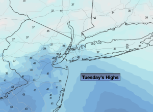
Tuesday:
Sun to clouds. Highs in the lower 40s. Northeast to Southeast winds at 5-10mph.
Tonight:
A few scattered showers early tonight, otherwise mostly cloudy. Not as cold as last night. Lows around 40º along the urban corridor,, the 30s inland. Southwest to West winds at 5mph.
Wednesday:
Mostly sunny. Highs in the lower 50s.
Thursday:
Mostly cloudy with on and off showers. Mild. Highs in the mid 50s.
Friday:
Mostly cloudy. Mild. Rain possibly developing during the evening. Highs in the mid 50s.
Saturday:
Mostly cloudy. Cooler. Highs in the lower 40s.