Synopsis:
Monday through Wednesday will feature a mix of clouds and sun as high pressure basically dominates. Readings will be above average. The average high is in the upper 30s to around 40º. Not feeling like February whatsoever.
On Thursday, low pressure will track from the Southern plains to the Eastern Great Lakes. This is a warm storm track, like all the storms this Winter season. On and off rain or showers are likely with balmy readings.
Friday will feature many sunny skies and guess what? Mild temperatures. We’ll be in between storm systems. The cold air is located over the Northern plains.
The next potential threat of precipitation will be Friday night into Saturday as another low develops to our South. At this time, mainly rain is expected. Yawn.
Stay tuned.
Keep it here for a no hype, no nonsense forecast.
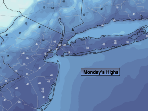
Monday:
Mostly sunny. Clouds over Eastern sections will eventually give way to brighter skies. Breezy and mild. Highs in the upper 40s to lower 50s. North to Northwest winds at 10-20mph with gusts to 25mph.
Tonight:
Clear with diminishing winds. Lows around freezing along the urban corridor,, the 20s to upper teens inland. North winds diminishing to 5mph.
Tuesday:
Sun to clouds. Highs in the mid 40s.
Wednesday:
Mostly sunny. Highs in the lower 50s.
Thursday:
Mostly cloudy with on and off rain or showers. Mild. Highs in the mid 50s.
Friday:
Sun and clouds. Mild. Highs in the mid 50s.