Synopsis:
Readings will soar today (from Saturday’s brutality) as the Arctic high rapidly moves offshore and a return Southwest flow develops.Temperatures will be around twenty degrees higher than Saturday. Today will definitely be the better half under a mix of clouds and sun. The tale of two seasons in one weekend.
Monday through Wednesday will feature a mix of clouds and sun as another high moves in from the West. Readings will be above average. The average high is in the upper 30s to around 40º. Not feeling like February whatsoever.
On Thursday low pressure will track from the Southern plains to the Eastern Great Lakes. This is a warm storm track, like all the storms this Winter season. Rain will develop by afternoon with well above average temperatures.
Stay tuned.
Keep it here for a no hype, no nonsense forecast.
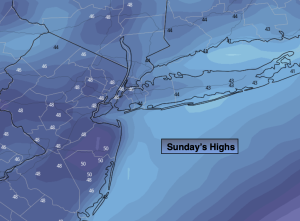
Sunday:
Clouds and sun. Much milder. Highs in the mid 40s. Southwest winds at 8-15mph.
Tonight:
Mostly cloudy. Milder than recent nights. Lows around 40º along the urban corridor,, the lower to mid 30s inland. Southwest to North winds at 5mph.
Monday:
Clouds to sun. Mild. Highs around 50º.
Tuesday:
Partly sunny. Highs in the mid to upper 40s.
Wednesday:
Mostly sunny. Highs in the lower 50s.
Thursday:
Mostly cloudy with rain developing. Mild. Highs in the lower to mid 50s.