Synopsis
A quiet last week of December is on the way. We’ll flirt with freezing today under a mix of sun and clouds. The frigid pool of air will finally move out of the region the next 24 hours and the winds will relax. A welcome change!
High pressure will build along the East coast the rest of the week. A developing Southwest flow will result in a warming trend. Temperatures will come out of the ice box and get to above average readings by midweek. Enjoy the break from the cold while it lasts!
Stay tuned.
Keep it here for a no hype, no nonsense forecast.
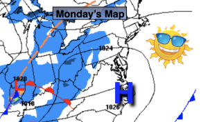
Monday:
Partly sunny. Not as harsh. Highs around freezing. West winds at 8-12mph.
Tonight:
Mostly cloudy. Lows in the mid 20s along the urban corridor to the teens and 20s inland. West winds at 5mph.
Tuesday:
Mostly sunny. Highs in the mid 30s.
Wednesday:
Sunny. Milder. Highs in the mid 40s.
Thursday:
Sunny. Mild. Highs in the upper 40s.
Friday:
Mostly sunny. Mild. Highs around 50º.