Synopsis:
Happy Hanukkah & Happy Winter!
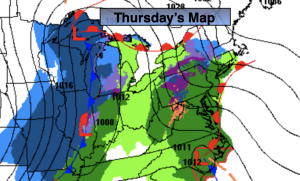
A storm will begin to take shape over the Midwest today at the same time a second low will develop over North Carolina. This low will move North along with it a slug of rain. The rain will develop within a few hours of midday depending on location. Highs will be a few degrees above the average of 42º.
The storm over the Great Lakes will become very intense. Blizzard conditions and very strong winds are expected in this region. We are on the warm side of the storm. Rain may become heavy at times tonight into early Friday morning. One to two inches of rain is expected. Winds will increase and become quite strong. It’ll be balmy Friday with most readings soaring into the 50s. Friday will not be a washout. In fact after the early morning rain ends only showers are expected that will most likely change to snow showers as one of the sharpest Arctic front I’ve seen in years plows through. Winds will gust to 50mph before and after the front moves through. Temperatures will go from the 50s into the 20s within 4 hours. The sun will shine once the front moves through Friday afternoon.
Saturday, Christmas Eve will be be frigid compared to what we experienced 24 prior. Readings will only be in the 20s for highs and the wind will add a bite! Wind chills will be in the single digits and teens. Get ready for a MAJOR shock. Skies will at least be bright.
Christmas Day will be frigid. Despite the sunshine readings will remain in the 20s. This will be one of the coldest Christmas’ in years!
We’ll stay in the ice box Monday under a bright sky.
Stay tuned.
Keep it here for a no hype, no nonsense forecast.
Tranquil conditions are expected through Wednesday as high pressure dominate.
Thursday:
Rain developing from Southwest to Northeast during the midday hours. Becoming breezy late. Highs in the 30s well inland the 40s at the coast. East winds increasing later in the day to 10-20mph.
Tonight:
Rain, heavy at times. Windy. Mild with rising overnight temperatures. Readings will get into the 50s along the coast, the 40s inland. Southeast to East winds 15-30mph with gusts to 45mph at the coast.
Friday:
Early morning rain, otherwise mostly cloudy with any scattered showers changing to snow showers midday. Windy. Highs in the 50s to around 60º South. Winds gusting to 50mph. Tumbling temperatures during the afternoon into the 20s and teens by dark!
Christmas Eve:
Sunny and Frigid. Windy. Highs only in the 20s. Wind chills in the teens.
Christmas Day:
Sunny and Frigid. Breezy. Highs only in the 20s. Wind chills in the teens.
Monday:
Sunny. Cold. Highs around 30º.