Synopsis:
Happy Hanukkah & Happy Winter!
High pressure overhead today will result in a bright and chilly start to Winter. The solstice occurs at 4:48PM. This is the exact time when the sun’s rays is at the Tropic of Capricorn. Daylight hours will increase from here on forward!
The well advertised storm for late week in the Eastern one half of the country will develop on Thursday over the Southern Plains. The track will be well West of our region and in to the Great Lakes by late Friday. This is a warm solution and will be a rain event. At the onset, the precipitation on Thursday afternoon may start as mix North and West but it will be short-lived as the mix will quickly change over to rain.
This will be a monster of a storm. Blizzard conditions and very strong winds are expected over the Great Lakes. Again, we are on the warm side. Rain may become heavy at times Thursday night into early Friday morning. Winds will increase and become quite strong. It’ll be balmy Friday with most readings soaring into the 50s. Friday will not be a washout. In fact after the early morning rain ends only showers are expected that will most likely change to snow showers as one of the sharpest Arctic front I’ve seen in some time plows through. Winds will gust to 50mph before and after the front moves through. Temperatures will go from the 50s into the 20s within 4 hours. The sun will shine once the front moves through Friday afternoon.
Saturday, Christmas Eve will be be frigid compared to what we experienced 24 prior. Readings will only be in the 20s for highs and the wind will add a bite! Get ready for a MAJOR shock.
Christmas Day will be frigid. Despite the sunshine readings will remain in the 20s. This will be one of the coldest Christmas’ in years!
Stay tuned.
Keep it here for a no hype, no nonsense forecast.
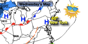
Tranquil conditions are expected through Wednesday as high pressure dominate.
Wednesday:
Sunny. Highs around 40º. North to Southeast winds less than 5mph.
Tonight:
Increasing clouds late. Lows in the mid 30s in the City, the teens and 20s inland. Temperatures will rise some late tonight. Southeast to East winds less than 5mph.
Thursday:
Thickening clouds. Rain most likely developing during the mid to late afternoon. A low potential for a mix for a time well inland. Becoming Breezy. Highs in the 30s well inland the 40s at the coast.
Friday:
Early morning rain, otherwise mostly cloudy with scattered showers changing to snow showers midday. Windy. Highs in the 50s to around 60º South. Winds gusting to 50mph. Tumbling temperatures during the afternoon into the 20s by dark!
Christmas Eve:
Sunny and Frigid. Windy. Highs only in the 20s.
Christmas Day:
Sunny and Frigid. Windy. Highs only in the 20s.