Synopsis:
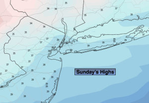
The forecast will be a familiar one for Sunday as the Northwest flow dominates. Winds will be gusty at times around a Canadian Maritimes low. Highs will be below the average of the lower 40s under a mix of sun and clouds.
Tranquil conditions are expected for the beginning and mid portion of the up coming week as high pressure moves in. The sun will dominate and readings will be just below average. Winter arrives on Wednesday.
The well advertised storm for late week in the Eastern one half of the country will develop on Thursday over the Southern Plains. All of the computer models have come into fairly good agreement that the track will be well West of our region. A warm solution and less frozen precipitation. This forecast has increased in confidence. At the onset, the precipitation on Thursday may start as mix, especially inland. A change to rain is anticipated in all areas.
Stay tuned.
Keep it here for a no hype, no nonsense forecast.
Sunday:
Partly sunny. Chilly. Highs in the 30s to around 40º. West to Northwest winds at 8-15mph.
Tonight:
Party cloudy. Lows in the 20s to around 30º along the urban corridor. West winds at 8-12mph.
Monday:
Mostly sunny. Highs around 40º.
Tuesday:
Sunny. Highs in the lower 40s.
Wednesday:
Sunny. Highs around 40º.
Thursday:
Thickening clouds. A mix, especially inland, changing to rain. Highs in the 30s to lower 40s.