Synopsis:
The last weekend of Autumn looks bright and chilly as a Northwest flow dominates. Winds will be gusty at times around an exiting storm off the Northern New England coast. Highs will be near the average of the lower 40s.
Tranquil conditions are expected for the beginning and mid portion of the up coming week as high pressure moves in. The sun will dominate and readings will be just below average. Winter arrives on Wednesday.
The well advertised storm for late week in the Eastern one half of the country will develop. The question is where? At this time the trend has been for a farther West placement. If this were to occur, it would be warmer solution and less frozen precipitation. This is over 5 days away. Please don’t listen to the specifics of any forecast- it’s way too soon. The timing would be later Thursday into Friday.
Stay tuned.
Keep it here for a no hype, no nonsense forecast.
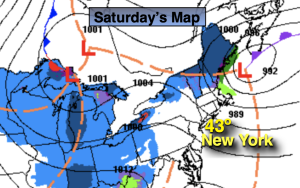
Saturday:
Partly sunny. Breezy. Highs in the lower 40s. West to Northwest winds at 15-25mph.
Tonight:
Party cloudy. Lows in the 20s to lower 30s along the urban corridor. West winds at 8-12mph.
Sunday:
Partly sunny. Chilly. Highs in the upper 30s.
Monday:
Mostly sunny. Highs around 40º.
Tuesday:
Sunny. Highs in the lower 40s.
Wednesday:
Sunny. Highs around 40º.