Synopsis:
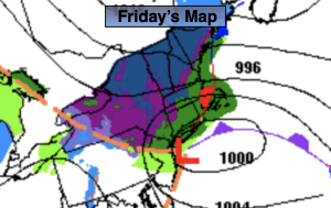
Low pressure on the NJ coast will slowly move Northeast to Long Island today. On and off rain is likely. There will be dry times especially later in the day. Winds will be gusty at the coast.
The storm will finally pull away from our area tonight. Any areas of rain will end this evening and skies will become partly cloudy overnight.
The weekend looks bright and chilly as a Northwest flow develops. Highs will be near the average of the lower 40s.
Tranquil conditions are expected for the beginning of the week as high pressure moves in.
There is a signal on the computer models that a storm will form late next week along the coast. This is over 6 days away. Please don’t listen to the specifics of any forecast- it’s way too soon.
Stay tuned.
Keep it here for a no hype, no nonsense forecast.
Friday:.
On and off rain. Windy at the coast. Highs in the 40s, the 30s well inland. Northeast to Northwest winds at 15-25mph with gusts to 45 at the coast.
Tonight:
Any leftover areas of rain will end, otherwise becoming partly cloudy overnight. Lows in the mid 30s in the City, the upper 20s inland. West winds at 10-20mph with a few higher gusts.
Saturday:
Partly sunny. Highs in the lower 40s.
Sunday:
Partly sunny. Highs in the upper 30s.
Monday:
Mostly sunny. Highs around 40º.
Tuesday:
Sunny. Highs in the lower 40s.