Synopsis:
The sun will finally return today as drier air moves in from the West. Readings will still be above the average high of 46º. High pressure over Quebec will dominate our weather Friday and Saturday. A mix of sun and clouds is expected with a return to more December-like readings.
Sunday will feature increasing clouds as a clipper works Southeast from the Great Lakes. The potential is now there for light rain mixed with light wet snow North and West during the afternoon. We’ll have to watch the latest trends with this system as rain and or wet snow may continue into Sunday night.
The clipper will deepen and move off the coast rapidly Monday. Any precipitation looks to end by sunrise. More clouds than sun is expected.
Stay tuned.
Keep it here for a no hype, no nonsense forecast.
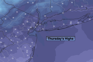
Thursday:
Mostly sunny. Mild. Highs in the lower 5os. Northwest winds at 10-20mph.
Tonight:
Partly cloudy. Lows in the mid 30s in the City, the 20s to lower 30s inland. North winds at 8-12mph.
Friday:
Mostly sunny. Highs in the mid 40s.
Saturday:
Mostly sunny. Highs in the mid 40s.
Sunday:
Thickening clouds. Chance of a bit of light rain mixed with light wet snow during the afternoon. Highs 40º-45º.
Monday:
More clouds than sun. Highs in the lower 40s.