Synopsis:
Weak fronts and an area of low pressure will move in from the West. Ahead of it mild air will be brought up from the South. Showers will develop toward midday. A period of rain is likely tonight. On and off showers are in the forecast for Wednesday (mainly in the morning) as the front will be sluggish moving off the coast.
A break from the wet conditions is expected for Thursday.
Low pressure will move from the Ohio Valley and weaken considerably as it approaches the Mid-Atlantic coast on Friday. At this time I am keeping showers out of the forecast.
Saturday looks bright and chilly as high pressure funnels down from Quebec.
Stay tuned.
Keep it here for a no hype, no nonsense forecast.
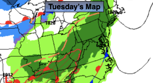
Tuesday:
Scattered showers developing toward midday. Mild. Highs in the mid 50s. Southeast winds at 5-10mph.
Tonight:
Rain. Mild. Lows around 50º in the City (this is warmer than the average high of 47º), the 40s inland. Light Southeast wind.
Wednesday:
Cloudy with scattered showers, mainly in the morning. Mild. Highs in the upper 50s.
Thursday:
Mostly sunny. Mild. Highs in the lower to mid 5os.
Friday:
Mostly cloudy. Highs in the mid 40s.
Saturday:
Mostly sunny. Highs in the mid 40s.