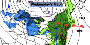
Synopsis:
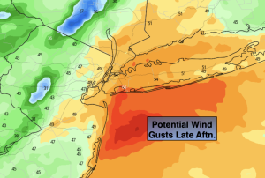
A cold front will approach today. Rain will develop later this morning. Once the warm sector ahead of the front moves into our area temperatures will pop and winds will increase dramatically. Wind gusts later this afternoon will reach 50mph at the coast. Please tightly secure any holiday decorations as they may become someone else’s issue. The rain will taper off this evening from West to East.
It’ll be windy and cold overnight with with clearing skies.
December’s debut on Thursday will be more typical of the season with colder readings and a gusty wind as a Canadian airmass moves in. Sunny, chilly conditions will continue for Friday. Both days will feature readings a few degrees below average high of 49º.
A mix of sun and clouds is expected for Saturday. A few showers are possible as a cool front approaches. It’ll be a mild day.
Sunday will be the better half of the weekend with bright skies and chilly readings as another high pressure system works in .
Stay tuned.
Keep it here for a no hype, no nonsense forecast.
Wednesday:
Rain developing by mid morning. Becoming windy. Mild. Highs in the mid to upper 50s. Southeast to Southwest winds at 15-30mph with gusts to 50mph + at the coast.
Tonight:
Early evening rain East otherwise becoming clear and cold. Remaining windy. Lows in the mid 30s in the City, the 20s inland. West to Northwest winds at 15-30mph with gusts to 40mph.
Thursday:
Mostly sunny, windy and colder. Highs in the mid 40s.
Friday:
Sunny and chilly. Highs in the mid 40s.
Saturday:
Mostly cloudy with a few showers possible. Mild. Highs in the mid to upper 50s.
Sunday:
Sunny. Cooler. Highs in the mid to upper 40s.