Synopsis:
The last weekend of October will be a winner. High pressure will be responsible for abundant sunshine and seasonable readings. Enjoy what this season has to offer!
On Halloween moisture will be building around the departing high as a Southerly flow takes hold. It now looks like any isolated showers will hold off until later in the day or at night. The forecast has definitely become more optimistic for trick or treaters!
Scattered showers are possible Tuesday as we welcome November as a trough of low pressure moves through. Temperatures will be well above the average highs of the upper 50s. Wednesday’s and Thursday’s forecast will be a familiar one with mild readings and sunny skies as high pressure dominates.
Stay tuned.
Keep it here for a no hype, no nonsense forecast.
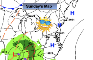
Sunday:
Mostly sunny. Highs in the lower 60s. Northeast to Southeast winds at 5mph.
Tonight:
Partly cloudy. Not as cold as recent nights. Lows in the lower in the City, the 30s & 40s inland. Southeast winds less than 5mph.
Halloween:
Sun and clouds. Isolated showers possible late. Milder. Highs in the mid 60s.
Tuesday:
More clouds than sun. Scattered showers possible. Highs in the upper 60s.
Wednesday:
Sunny. Highs in the upper 60s.
Thursday:
Sunny. Highs in the mid to upper 60s.