Synopsis:
Our unsettled conditions will continue through today. The threat of scattered showers, areas of drizzle and fog are in the forecast as the flow will be coming off the ocean as a weak cool front approaches from the West. It will not be a washout. Temperatures will continue to be above average.
We’ll finally get a break from the dismal weather by tomorrow. High pressure moving in will aid in getting our skies finally bright. It’ll still be mild. Friday through the weekend will be winners with more seasonable readings (average highs are around 60º) as the flow comes down from the Canadian maritimes.
Stay tuned.
Keep it here for a no hype, no nonsense forecast.
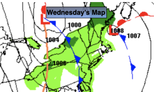
Wednesday:
Mostly cloudy. Areas of fog in the morning. Scattered showers possible. Warm. Highs in the 60s to to lower 70s. Northeast to Southwest winds at 5mph.
Tonight:
Clearing skies. Lows in the 50s throughout. West to Northwest winds at 5-10mph.
Thursday:
Sunny. Mild. Highs in the upper 60s.
Friday:
Sunny. More seasonable. Highs in the lower 60s.
Saturday:
Sunny. Highs around 60º.
Sunday:
Mostly sunny. Highs in the lower 60s.