Synopsis:
The NYC tri-state area will continue with grey skies and times of rain through Wednesday as low pressure remains basically stationary off the Mid-Atlantic coast. On and off rain is expected. The rain maybe heavy at times into tonight. It will be raw with readings at least ten to fifteen degrees below the average high of 70º. The wind will add to the misery due to the difference in pressure with a strong high to the North and low pressure off the coast.
By Thursday the high to the North will win the battle as low pressure moves offshore. The sun will return and readings will pop into the lower 70s. A dramatic and welcome change.
Friday will be a Fall classic with plenty of sun and mild readings ahead of a cold front.
Behind the front on Saturday readings will be several degrees below the average high of 68º despite the sunhine.
Keep it here for a no hype, no nonsense forecast.
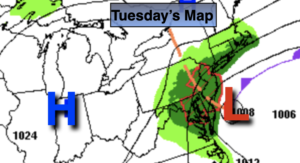
Tuesday:
On and off rain. Very cool and breezy. Highs in the lower to mid 50s.Northeast winds at 15-25mph with higher gusts.
Tonight:
On and rain. Breezy. Lows in the 40s to around 50º in the City. Northeast winds at 15-25mph with higher gusts.
Wednesday:
On and off rain. Very cool. Highs in the upper 50s.
Thursday:
Sunny. Warmer. Highs in the lower 70s.
Friday:
Sunny. Mild. Highs in the lower to mid 70s.
Saturday:
Mostly sunny. Cooler and breezy. Highs only around 60º.