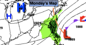
Synopsis:
The NYC tri-state area is in store for a couple more days of grey skies and times of rain as low pressure remains basically stationary off the Mid-Atlantic coast through Tuesday. On and off rain is expected. The least amount of rain will fall to the North of the City, the steadiest and heaviest will fall South of the City. It will be raw with readings at least ten degrees below the average high of 70º. The wind will add to the misery due to the difference in pressure with a strong high to the North and low pressure off the coast.
By Wednesday the high to the North will win the battle as low pressure moves offshore. Scattered morning showers should give way to the appearance of the sun.
Thursday and Friday will be October gems with abundant sunshine and moderating temperatures.
Keep it here for a no hype, no nonsense forecast.
Monday:
Mostly cloudy. On and off showers. Steadier rain over Southern areas. Breezy and unseasonably cool. Highs in the upper 50s. Northeast winds at 15-25mph with higher gusts.
Tonight:
On and rain. Breezy. Lows in the 40s throughout. Northeast winds at 15-25mph.
Tuesday:
On and off rain. Very cool and breezy. Highs in the mid 50s.
Wednesday:
Chance of morning showers, otherwise some afternoon sun. Highs in the mid 60s.
Thursday:
Sunny. Warmer. Highs in the lower 70s.
Thursday:
Sunny. Highs in the lower 70s.