Synopsis:
The NYC tri-state area is in store for a couple more days of grey skies and times of rain as the remnants of Ian weaken and a secondary low develops off the coast Sunday and Monday. On and off rain is expected through Monday. It will be raw with readings at least ten degrees below the average high of 70º. The wind will add to the misery due to the difference in pressure with a strong high to the North and low pressure off the coast. Indoor activities will be a a premium as we begin the month of October.
By Tuesday the high to the North will win the battle as low pressure moves offshore. This should result in drier conditions and the appearance of the sun.
Wednesday and Thursday will be October gems with abundant sunshine and moderating temperatures.
Keep it here for a no hype, no nonsense forecast.
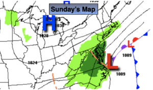
Sunday:
On and off rain. Steadiest from the City and to the South. Breezy. Highs in the upper 50s. Northeast winds at 15-25mph.
Tonight:
On and off drizzle and rain. Breezy. Lows in the lower 50s in the City, the 40s inland. Northeast winds increasing to 10-20mph.
Monday:
Mostly cloudy. Chance of on and off showers. Breezy. Highs in the upper 50s.
Tuesday:
Clouds and sun. Highs in the lower 60s.
Wednesday:
Partly sunny. Highs in the upper 60s.
Thursday:
Sunny. Warmer. Highs in the mid 70s.