Synopsis:
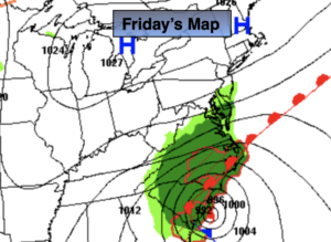
High pressure over the Northeast will keep us dry for one more day. Clouds will dominate though as the cloud shield moves up from the South as Hurricane Ian makes landfall in South Carolina. It’ll be a minimal hurricane but our hearts now go out to those in South and North Carolina.Readings today will be several degrees below the average high of 72º.
The NYC tri-state area is in store for several days of grey skies and times of rain as the remnants of Ian move in and a secondary low develops off the coast by early next week. We are not expecting severe conditions. The steadiest and heaviest rain looks to be Saturday. On and off rain or showers can be expected through Tuesday. It will be raw, especially this weekend with readings possibly remaining in the upper 50s this weekend. The wind will add to the misery. We’ll stay well below the average high of 70º the next 5 days.
Time to find those jackets and a good book.
Keep it here for a no hype, no nonsense forecast.
Friday:
Mostly cloudy. Times of sun. Highs in the mid 60s. Northeast winds at 5-10mph.
Tonight:
Cloudy with rain developing. Lows in the lower 50s in the City, the 40s inland. Northeast winds increasing to 8-15mph.
Saturday:
Rain. Breezy. Highs only in the upper 50s.
Sunday:
Mostly cloudy with a chance of some rain. Breezy. Highs in the 50s to around 60º.
Monday:
Mostly cloudy. Chance of on and off rain or showers. Breezy. Highs around 60º.
Tuesday:
Mostly cloudy. Chance of showers. Breezy. Highs in the lower 60s.