Synopsis:
High pressure over the Great Lakes and Northeast will be responsible for our Fall Classic today. Abundant sunshine is expected Readings will be several degrees below the average high of 72º.
Hurricane Ian, now a Tropical Storm, battered Florida the past 24 hours. Our hearts go out to those affected. Ian will move off the coast by Cape Canaveral today and head toward South Carolina on Friday.
Confidence has increased that remnant moisture will make it up here. Friday’s sky will go overcast by afternoon as the cloud shield works North from Ian. Saturday now looks to be a rainy day. There is a chance of some rain on Sunday depending on how the moisture field sets up with Ian’s remnants. We are not expecting severe conditions.
Keep it here for a no hype, no nonsense forecast.
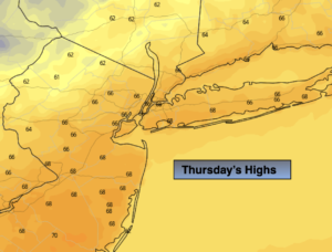
Thursday:
Sunny. Cooler. Highs in the mid to upper 60s. North winds at 8-15mph.
Tonight:
Mostly clear. Lows in the lower to mid 50s in the City, the 40s inland. Northeast winds at 5-10mph.
Friday:
Sun to clouds. Highs in the mid 60s.
Saturday:
Rain likely. Breezy. Highs in the lower 60s.
Sunday:
Mostly cloudy with a chance of some rain. Breezy. Highs in the mid 60s.
Monday:
Partly sunny. Breezy. Highs in the mid 60s.