Synopsis:
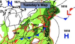
Low pressure will move from the New Jersey and slowly out to sea through Wednesday morning. On and off rain is in the forecast and it’ll be quite cool. The rain will be locally heavy.
A Flood Watch has been posted for the entire tri-state area through this evening. One to four inches of rain is possible by the time they system moves off the coast. Flooding of streets, highways, streams and rivers are possible. Never drive through a flooded roadway you don’t know how deep that water is. Turn around, Don’t drown.
Wednesday will still be damp and cool with scattered showers. The rain will be much lighter than today.
We’ll get a chance to dry out on Thursday as drier air works in from the North. The sun will dominate the sky into the weekend as high pressure takes over. A string of gorgeous September days are on the way with seasonable temperatures.
Keep it here for a no hype, no nonsense forecast.
Tuesday:
Periods of rain. Locally heavy at times. Chance of a thunderstorm. Much cooler. Highs in the lower 70s. Southeast to South winds at 8-12mph with gusts to 20mph during the afternoon.
Tonight:
On and off showers. Lows in the 60s throughout. Northeast winds at 10-20mph with gusts to 25mph.
Wednesday:
Mostly cloudy. Scattered showers. Highs in the lower 70s.
Thursday:
Mostly sunny. Highs in the upper 70s.
Friday:
Sunny. Highs around 80º.
Saturday:
Sunny. Highs around 80º.
Catch me Labor Day on the Fox Weather Stream from 1p-4p. Find us on Tubi, Roku TV and YouTube TV and as always the Fox Weather App. It’s Free!