Synopsis:
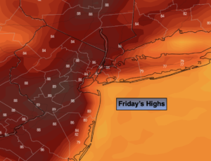
A nice close to the workweek is expected. Friday will feature a mix of sun and clouds as a weakening front moves our way. Readings will be close to the seasonal averages of the mid 80s.
Many areas will start the weekend off Wet. On Saturday a weak low from the South will move up into our region during the morning. A period of rain is likely just South of the City for the first half of the day. In the NYC vicinity showers are likely for a time, especially during the morning. It’ll be dry North of the City. Yep, it’s all about location. The showers will taper off from Northwest to Southeast during the early afternoon hours with much of the day being dreary at the NJ beaches.
Sunday will definitely be the the better half with abundant sunshine and warm readings as high pressure works in from the North.
Our fine July weather will continue into Monday. It’ll heat up on Tuesday as high pressure moves off the coast and a Southwesterly flow develops.
Stay tuned.
Keep it here for a no hype, no nonsense forecast.
Friday:
Sun and clouds. Highs in the mid 80s. Cooler at the coast. South winds at 5-10mph.
Tonight:
Thickening clouds with showers likely from the City and to the South and West after midnight. Lows around 70º in the City, the 60s North and West. South to North winds less than 5mph.
Saturday:
Steady rain to the South. Showers in the NYC vicinity. The rain will taper off from Northwest to Southeast during the early afternoon. Highs in the mid 70s in rain-cooled areas to the mid 80s to the North.
Sunday:
Sunny. Highs in the lower 80s.
Monday:
Sunny. Highs in the mid 80s.
Tuesday:
Sunny, hot and humid. Highs in the lower 90s.
Catch me on the Fox Business Network this weekend until 9am Weather Stream until 10am. Find us on Tubi, Roku TV and YouTube TV and as always the Fox Weather App. It’s Free!