Synopsis:
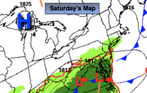
And that’s the weather-a dramatic improvement in the forecast for Saturday. The weak area of low pressure (that was forecast to give many areas from the City and to the South times of rain has fallen apart today. The good news is that most of the region will be dry and become mainly sunny. Well to the South over Southern NJ showers are possible for the first half of the day. Even here the sun may win the battle during the afternoon. Temperatures where the sun does shine will be near the seasonal averages of the mid 80s. It’ll be cooler to the South and at the coast.
Sunday will be a gem with abundant sunshine and warm readings as high pressure works in from the North.
Our fine July weather will continue into Monday. It’ll heat up on Tuesday and Wednesday as high pressure moves off the coast and a Southwesterly flow develops.
Stay tuned.
Keep it here for a no hype, no nonsense forecast.
Saturday:
Becoming mostly sunny in the NYC vicinity and all areas to the North, West and East. Mostly cloudy South with scattered showers this morning over Southern NJ. Here too the sun will win the battle this afternoon. Highs in the mid and upper 70s where the clouds hold tough and at the coast the mid 80s elsewhere. Northeast to Southeast winds at 5-10mph.
Tonight:
Clear and comfortable. Lows in the mid 60s in the City, the 50s North and West. Light Northeast wind.
Sunday:
Sunny. Highs in the lower 80s.
Monday:
Sunny. Highs in the mid 80s.
Tuesday:
Sunny, hot and humid. Highs in the lower to mid 90s. Scattered storms possible at night.
Wednesday:
Sunny, hot and humid. Highs in the lower 90s.
Catch me on the Fox Business Network this weekend until 9am Weather Stream until 10am. Find us on Tubi, Roku TV and YouTube TV and as always the Fox Weather App. It’s Free!