Synopsis:
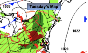
More clouds than sun is expected for Tuesday. There will be a noticeable increase in humidity by later in the day as a Southwest wind around high pressure develops. Scattered showers are possible by mid to late afternoon as a warm front pushes in. Scattered showers and storms are likely this evening and tonight as the front moves through.
The humidity will drop on Wednesday and the sun will dominate as high pressure moves in. Seasonable readings (in the mid 80s) are anticipated.
The forecast isn’t quite clear for Thursday and Friday as the computer models are not in agreement with frontal boundaries. At this time, I will include the threat of showers at times both days. It will not be a washout. This is a low confidence forecast. Please check back to see the latest update for this 48 hour period.
It looks like a decent start to the weekend with any clouds Saturday giving way to sunny skies.
Stay tuned.
Keep it here for a no hype, no nonsense forecast.
Tuesday:
Clouds and sun. More humid by later in the day. Scattered showers possible by later in the day. Highs in the mid 80s.
Tonight:
Scattered showers and storms. Muggy. Lows in the 60s throughout. Southwest to West winds at 8-12mph.
Wednesday:
Partly sunny. Less humid. Highs in the mid 80s.
Thursday:
Clouds, some sun. Potential for showers. Highs around 80º.
Friday:
Clouds, some sun. Potential for showers and storms. Highs in the lower 80s.
Saturday:
Morning clouds giving way to sunny skies. Highs in the mid 80s.
Catch me on the Fox Business Network this weekend until 9am Weather Stream until 10am. Find us on Tubi, Roku TV and YouTube TV and as always the Fox Weather App. It’s Free!