Synopsis:
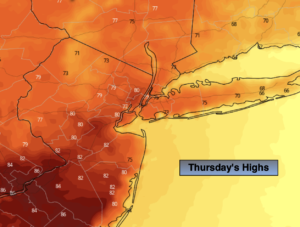
Thursday will be a battle between the clouds and sun. It’ll be warmer than yesterday. Readings in many areas will reach 80º with a wind off the land for a time. Another round of scattered storms will develop later this afternoon with an approaching cool front. Scattered showers and storms are likely tonight with the passage of the front.
Friday will be decent as the system moves off the coast. Any clouds will give way to sunny skies.
The first weekend of June will spectacular as high pressure dominates. Both days will feature abundant sunshine with readings near of just above the seasonal highs of the mid to upper 70s.
The fine conditions will continue into Monday.
Stay tuned.
Keep it here for a no hype, no nonsense forecast.
Thursday:
Clouds and sun. Much warmer. Late day scattered storms possible. Highs around 80º. Cooler at the coast. Southwest to Northwest winds at 5-10mph.
Tonight:
Scattered showers and thunderstorms. Lows in the lower 60s throughout. East winds at 5mph.
Friday:
Clouds to sun. Highs in the mid to upper 70s.
Saturday:
Sunny. Highs in the mid to upper 70s.
Sunday:
Sunny. Highs in the mid to upper 70s.
Monday:
Mostly sunny. Highs in the mid 70s.
Catch me on the Fox Weather Stream from 10am-1pm Wednesday. Find us on Tubi, Roku TV and YouTube TV and as always the Fox Weather App. It’s Free!