Synopsis:
Scattered storms are likely through early tonight with an approaching cool front. A Severe Thunderstorm Watch is in effect for Mercer, Monmouth and Ocean counties until 9PM. Keep an eye to the sky for threatening weather.
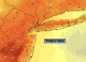
Friday will be decent as the cool front moves off the coast. Any clouds will give way to sunny skies. It’ll be much less humid and a fine day is on tap.
The first weekend of June will spectacular as high pressure dominates. Both days will feature abundant sunshine with readings near of just above the seasonal highs of the mid to upper 70s.
The fine conditions will continue into Monday.
Any sun on Tuesday will give way to afternoon showers as a front moves into the region.
Stay tuned.
Keep it here for a no hype, no nonsense forecast.
Tonight:
Scattered showers and thunderstorms. Lows in the lower 60s throughout. East winds at 5mph.
Friday:
Clouds to sun. Highs in the mid to upper 70s. Northeast to North winds at 5-10mph.
Saturday:
Sunny. Highs in the mid to upper 70s.
Sunday:
Sunny. Highs in the mid to upper 70s.
Monday:
Mostly sunny. Highs in the mid 70s.
Tuesday:
Morning sun to afternoon showers. Highs in the mid 70s.
Catch me on the Fox Weather Stream from 10am-1pm Wednesday. Find us on Tubi, Roku TV and YouTube TV and as always the Fox Weather App. It’s Free!