Synopsis:
Today will be the hottest day of the year so far. Readings will soar into the lower to mid 90s as we close out the month of May. The record high for Central Park is 96º set in 1939. That record should remain for at least one more year. The bubble of hot air around a Bermuda high is responsible for our mid-Summer feel.
A back door cold front will move into our area tonight from New England. This will put an end to our brief bout with Summer. Spotty showers are possible overnight.
June’s debut on Wednesday will feature a mix of clouds and some sun. Readings will be more seasonable with a wind off the cooler Atlantic. It’ll be much cooler to the east and warmer inland.
Two disturbances will ride rapidly through our region Wednesday Night and then again on Thursday night. Scattered showers and storms are possible during these times. During the day on Thursday partly sunny skies are expected.
Friday will be decent as the system moves off the coast. Any clouds will give way to sunny skies.
The start of the first weekend of June will spectacular as high pressure dominates. Saturday highs will be just above the seasonable averages of the mid 70s.
Stay tuned.
Keep it here for a no hype, no nonsense forecast.
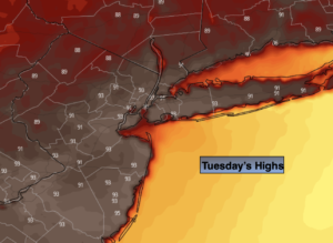
Tuesday:
Hazy and hot. Highs in the lower to mid 90s. West to Northwest winds at 8-12mph.
Tonight:
Mostly cloudy. Spotty showers possible. Lows in the lower to mid 60s throughout. Northeast winds at 5mph.
Wednesday:
Clouds and sun. More seasonable. Highs in the mid 70s in the City, much warmer to the West, cooler to the East.
Thursday:
Sun and clouds. Late day scattered storms possible. Highs in the mid to upper 70s.
Friday:
Clouds to sun. Highs in the upper 70s.
Saturday:
Sunny. Highs in the upper 70s.
Catch me on the Fox Business Network from 6am-9am this weekend and on the Weather Stream until Noon. Find us on Tubi, Roku TV and YouTube TV and as always the Fox Weather App. It’s Free!