Synopsis:
A weak low will move through the region early this morning with scattered showers. Once this feature moves off the coast we’ll be left with grey skies, maybe a bit of drizzle from time to time and much cooler readings. Well to the South and West readings may get into the 60s.
Skies will remain cloudy tonight with a wind of the Atlantic.
Tuesday will feature clouds giving way to partly sunny skies with high pressure moving overhead. Another system will move into the region on Wednesday with another round of showers. Skies once again will become partly sunny for Thursday as another high pressure ridge moves overhead. Another low will move toward the East coast on Friday with round 3 of late day showers. Needless to say, every other day there’ll be a chance of showers sandwiched in with days of sunshine. Spring in the Northeast!
Stay tuned.
Keep it here for a no hype, no nonsense forecast.
Monday:
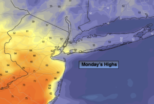
Cloudy with morning showers. Much cooler. Highs in the mid to upper 50s, possible 60s South and West. East to Northeast winds at 5-10mph.
Tonight:
Cloudy. Lows around 50º in the City, the 40s inland. North winds at 5mph.
Tuesday:
Clouds to sun. Highs in the lower 60s.
Wednesday:
Mostly cloudy with scattered showers. Highs around 60º.
Thursday:
Partly sunny. Highs around 70º.
Friday:
Mostly cloudy with showers possible during the afternoon. Highs in the lower 60s.
Catch me on the Fox Business Network this weekend from 6am-9am and the Fox Weather Stream until Noon. Find us on Tubi, Roku TV and YouTube TV and as always the Fox Weather App. It’s Free!