Synopsis:
It’ll be unseasonably cool today. The wind will add to the chill. Readings will be at least ten degrees lower than the average high of 66º. Not feeling like late April for sure.
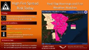
Please use caution outdoors with flammables. A Red Flag Warning has been posted. Dry conditions, gusty winds and low relative humidity. Could lead to rapid growth of any wildfires that due develop.
Chilled sunshine will be with us through the end of the week as the Northwesterly flow will be persistent. This will result in our continuation of below average temperatures.
Saturday will be bright with the breeze not being an issue as high pressure moves overhead. We greet May on Sunday and readings will finally feel like they should for this time of the year!
The next chance of showers comes Monday.
Stay tuned.
Keep it here for a no hype, no nonsense forecast.
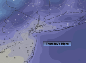
Thursday:
Mostly sunny, breezy and very cool. Highs in the mid 50s. Northwest winds at 15-25mph with gusts to 30mph.
Tonight:
Mostly clear and cold. Lows in the upper 30s in the City, the upper 20s and 30s inland. Northwest wind 15-25mph and diminishing.
Friday:
Mostly sunny. Highs around 60º.
Saturday:
Sunny. Highs in the lower to mid 60s.
Sunday:
Mostly sunny. Highs in the upper 60s.
Monday:
Mostly cloudy with scattered showers. Highs in the mid 60s.
Catch me on the Fox Weather Stream Thursday from 1pm-4pm. Find us on Tubi, Roku TV and YouTube TV and as always the Fox Weather App. It’s Free!