Synopsis:
A cold front will move through the region tonight. Scattered showers are likely through the first half of the night.
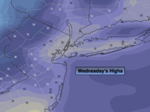
The sun will make a appearance Wednesday. It’ll be unseasonably cool as a Canadian air filters in. The wind will add to the chill. Readings will be at least ten degrees lower than the average high of 66º. Not feeling like late April for sure.
Chilled sunshine will be with us through the end of the week as the Northwesterly flow will be persistent. This will result in our continuation of below average temperatures.
Saturday will be bright with the breeze not being an issue as high pressure moves overhead. We greet May on Sunday and readings will finally feel like they should for this time of the year!
Stay tuned.
Keep it here for a no hype, no nonsense forecast.
Tonight:
Scattered showers. Becoming partly cloudy late. Lows in the 40s throughout. Northwest wind increasing to 8-15mph.
Wednesday:
Partly sunny, breezy and cool. Highs in the mid 50s. Northwest winds at 15-25mph with gusts to 30mph.
Thursday:
Mostly sunny and cool. Highs in the mid 50s.
Friday:
Mostly sunny. Highs around 60º.
Saturday:
Sunny. Highs in the lower 60s.
Sunday:
Sunny. Highs in the upper 60s.
Catch me on the Fox Weather Stream on Wednesday from 10a-1pm. Find us on the stream on Tubi, Roku TV and YouTube TV and as always the Fox Weather App. It’s Free!