Synopsis:
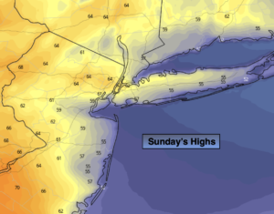
Pleasant conditions will continue through the second half of the weekend as high pressure remains in control. Temperatures will be cooler than normal (the average high temperature is 65º). Today’s temperature all depend on location. West of the City readings may reach well into the 60s, to the East temperatures will be much cooler. This is due to the wind off the colder Atlantic. Mostly sunny skies are expected.
Monday will be pleasant under a mix of sun and clouds as the high slips off the coast.
Tuesday will feature a cold front approaching showers are likely.
More sunshine is expected for Wednesday; it’ll be cool and breezy as a Canadian filters in. Chilled sunshine will be with us into Thursday.
Stay tuned.
Keep it here for a no hype, no nonsense forecast.
Sunday:
Mostly sunny. Highs around 60º in the City. Cooler East, Warmer West. Northeast to Southeast winds at 10-15mph.
Tonight:
Mostly clear. Lows in the 40s throughout. Light Southeast wind.
Monday:
Sun and clouds. Highs in the lower 60s.
Tuesday:
Mostly cloudy with scattered showers. Highs in the lower to mid 60s.
Wednesday:
Partly sunny, breezy and cool. Highs in the mid to upper 50s.
Thursday:
Mostly sunny and cool. Highs in the mid to upper 50s.
Catch me on the Fox Business Network this weekend from 6am-9am and on the Fox Weather Stream until Noon. Find us on the stream on Tubi, Roku TV and YouTube TV and as always the Fox Weather App. It’s Free!