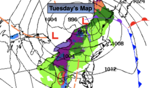
Synopsis:
The storm that gave the region a quick hit of heavy rain and wind will move into Eastern New England today. Morning clouds will give way to partly sunny skies. It will still be chilly and breezy with readings around ten degrees below the average high of 63º.
Partly cloudy skies and brisk conditions are expected overnight. All readings will remain above freezing.
Wednesday will be bright and pleasant as high pressure builds overhead. Pleasant conditions will continue into Saturday as high pressure remains in control.
Stay tuned.
Keep it here for a no hype, no nonsense forecast.
Tuesday:
Clouds and sun breezy and chilly. Highs in the lower to mid 50s. West winds at 15-25mph with higher gusts.
Tonight:
Partly cloudy. Breezy. Lows around 40º in the City, the 30s inland. West winds at 10-20mph.
Wednesday:
Sunny. Highs around 60º.
Thursday:
Partly sunny. Highs in the lower 60s.
Friday:
Mostly sunny. Milder. Highs in the upper 60s.
Saturday:
Partly sunny. Highs in the lower 60s.
Catch me on the Fox Business Network this weekend from 6am-9am and on the Fox Weather Stream until Noon. Find us on the stream on Tubi, Roku TV and YouTube TV and as always the Fox Weather App. It’s Free!