
Synopsis:
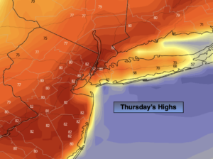
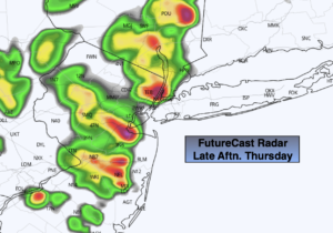
A cool front will approach today. A mix of sun and clouds is expected. Ahead of the system temperatures will once again reach the lower 80s away from the Ocean. It’ll be cooler at the immediate coast and over Long Island. Scattered showers and storms will develop by mid to late afternoon. Some of the storms may become strong to isolated severe. Keep an eye to the sky for threatening weather.
Friday should be mild under a mix of sun and clouds. Highs will be a several degrees above the average high of 61º.
The Easter Holiday weekend should be decent. Partly sunny skies are expected both days. A shower can’t be ruled out later Saturday with the passage of a cold front. Dry Easter bonnets are expected Sunday as high pressure moves in. Temperatures will be a few degrees above the average on Saturday. A chilly breeze will be with us on Easter with readings several degrees below average.
Sun to give way to clouds on Monday as a system begins to move in from the South.
Stay tuned.
Keep it here for a no hype, no nonsense forecast.
Thursday:
Partly sunny. Warmer. Scattered late day storms. Highs in the lower 80s in the City and to the West. Cooler East. Southwest 10-20mph with higher gusts.
Tonight:
An evening shower or storm, otherwise partly cloudy. Lows around 50º in the City, the upper 30s and 40s inland. Northwest to West winds 10-15mph and diminishing.
Friday:
Partly sunny. Highs in the upper 60s..
Saturday
Sun and clouds. Scattered afternoon showers. Highs in the mid 60s.
Easter Sunday:
Party sunny, breezy and cooler. Highs in the mid 50s.
Monday:
Sun to clouds. Highs in the mid 50s.
Catch me on the Fox Weather Stream from 6am-10am Thursday and Friday. Find us on Tubi, Roku TV and YouTube TV and as always the Fox Weather App. It’s Free!