Synopsis:
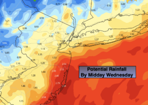
Rain will continue this morning as low pressure moves from Virginia to just off the NJ coast. The rain will be heavy at times for the morning commute. Ponding of water and local flooding of streets and highways are possible. Never drive through a flooded roadway. The heaviest rain looks to fall along coastal areas. One to two inches of rain is possible. The rain will taper by mid-day with skies will remaining mainly cloudy.
Another round of rain will work in for Thursday as a second system moves in from the South and West. Readings will be several degrees below the average high of 57º.
The low will move off the coast early Friday morning. Skies will become partly sunny but the wind will be busy. Spotty showers are possible both Friday afternoon through the weekend as an upper level low deepens over the Northeast. Much of the time will be dry. Readings will be near the average highs of the upper 50s. Cooler readings are expected on Sunday.
Stay tuned.
Keep it here for a no hype, no nonsense forecast.
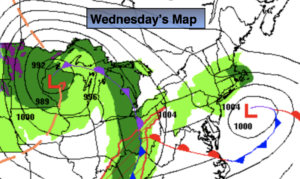
Wednesday:
Heavy morning rain, otherwise remaining cloudy for the afternoon. It will be a dry PM. Highs in the lower to mid 50s. Northeast winds at 15-25mph and diminishing during the afternoon.
Tonight:
Cloudy with an isolated shower. Lows in the 40s throughout. Northeast winds at 5-10mph.
Thursday:
On and off rain. Highs in the mid 50s.
Friday:
Sun and clouds. Breezy. Isolated afternoon showers. Highs around 60º.
Saturday:
Sun and clouds. Breezy. Scattered afternoon showers. Highs in the upper 50s.
Sunday:
Sun and clouds. Breezy. Scattered afternoon showers. Highs in the mid 50s.
Catch me on the Fox Weather Stream from 10am-1pm on Wednesday. Find us on Tubi, Roku TV and YouTube TV and as always the Fox Weather App.