Synopsis:
An upper level low will move through the region today with more clouds than sun, scattered showers and gusty winds. Readings will be near the average high of 55º than drop to around 50º later this April 1st afternoon.
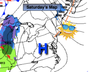
High pressure will dominate on Saturday resulting in mainly sunny, seasonable conditions.
A weak disturbance will slide through the region on Sunday. More clouds are expected and spotty showers are likely.
A tranquil start is anticipated for the beginning of next week with high pressure in control.
The next chance of rain will come Wednesday with an approaching low.
Stay tuned.
Keep it here for a no hype, no nonsense forecast.
Catch me on the Fox Business Network this weekend from 6am-9am and on the Fox Weather Stream from 6am-Noon. Find us on Tubi, and YouTube TV and as always the Fox Weather App.
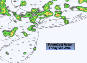
Friday:
Mostly cloudy with scattered afternoon showers. Breezy. Highs in the lower to mid 50s. West to Northwest winds at 15-30mph with higher gusts.
Tonight:
Evening scattered showers, otherwise partly cloudy, chilly and breezy. Lows in the upper 30s in the City, around 30º inland. West to Northwest winds at 15-30mph.
Saturday:
Mostly sunny. Seasonable. Highs in the mid 50s.
Sunday:
Mostly cloudy. Scattered showers possible. Highs around 50º.
Monday:
Mostly sunny. Highs in the mid 50s.
Tuesday:
Sun to clouds. Highs in the mid to upper 50s.
Wednesday:
Mostly cloudy. Showers likely. Highs in the mid to upper 50s.