
Synopsis:
Today will feature a warm push as readings ahead of a cool front approach 70º! A big change for sure. It’ll be cooler over Long Island and coastal regions. Spotty showers just about anytime and so is a bit of sun. Much of the day will be rain-free.
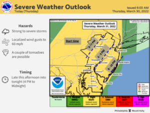
As the front approaches this evening and night showers and thunderstorms are likely. Some of the storm may turn severe from the City and to the South and West. This is the area that will become the warmest and most unstable aiding in the development of thunderstorms.
Behind the front on Friday which is the first day of April, it’ll be partly sunny. Winds will increase during the day. Temperatures will be a few degrees above the average high of 54º.
High pressure will dominate on Saturday resulting in mainly sunny, seasonable conditions.
A weak disturbance will slide through the region on Sunday. More clouds are expected and spotty showers are possible.
A tranquil start is anticipated for the beginning of next week.
Stay tuned.
Keep it here for a no hype, no nonsense forecast.
Catch me on the Fox Weather Stream between 10am-1pm on Friday Find us on Tubi, and YouTube TV and as always the Fox Weather App.
Thursday:
Clouds, some peeks of sun. Much warmer. Spotty showers. Much of the day will be dry. Highs in the mid 60s to near 70º. Cooler out East and along the coast. South winds at 15-25mph with higher gusts later in the day.
Tonight:
Scattered showers and thunderstorms this evening. Some of the storms may become severe. Partly cloudy late. Mild. Lows in the lower 50s in the City, the 40s inland. South to West winds gusty during the evening at 15-30mph with higher gusts and diminishing late.
Friday:
Partly sunny and mild. Becoming windy. Highs in the upper 50s.
Saturday:
Mostly sunny. Seasonable. Highs in the mid 50s.
Sunday:
Mostly cloudy. Spotty showers possible. Highs in the lower 50s.
Monday:
Partly sunny. Highs in the upper 50s.