Synopsis:
An upper level low will move through the Northeast today. This will result in an unstable atmosphere. Morning sun will give way to mainly cloudy skies. A cold front will move through late in the day with and scattered showers and snow showers in spots. Readings will be several degrees below the average of 53º.
Tonight will be frigid with lows in the teens and 20s.
Monday will feel more like Winter than Spring as a Canadian airmass settles over the region. Readings will remain in the 30s for highs and the wind will add a bite. Tuesday won’t be as harsh but the chill will continue.
On Wednesday a warm front will approach. More clouds than sun is expected with the chance of spotty showers.
Thursday will feature mild readings ahead of a cold front. Showers are possible.
Stay tuned.
Keep it here for a no hype, no nonsense forecast.
Catch me on the Fox Business Network this weekend between 6am-9am and on Fox Weather Stream between 6am-Noon. Find us on Tubi, and YouTube TV and as always the Fox Weather App.
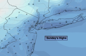
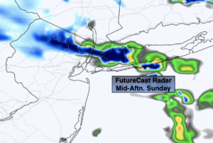
Sunday:
Sun to clouds. Isolated showers and snow showers during the afternoon. Windy and cooler. Highs in the mid 40s. West to Northwest winds at 15-25mph with gusts to 30mph.
Tonight:
Evening scattered snow showers, otherwise skies will be partly cloudy. Frigid Lows in the lower 20s in the City, the teens inland. Wind chills in the single digits and teens. Northwest winds at 1525mph with higher gusts.
Monday:
Mostly sunny, breezy and cold. Highs only in the lower to mid 30s. Morning wind chills in the single digits and teens.
Tuesday:
Mostly sunny. Chilly. Highs in the mid 40s.
Wednesday:
Mostly cloudy. Spotty showers possible during the afternoon. Cool. Highs only in the upper 40s.
Thursday:
Mostly cloudy. Milder. Showers possible. Cool. Highs only in the lower 60s.