Synopsis:
An upper level low will move through the Northeast today. This will result in an unstable atmosphere. Clouds will win the battle and scattered showers are possible anytime after mid-morning. A thunderstorm is even possible that may be accompanied by small hail. Readings will be near or slightly above average of 53º.
A blast of Canadian air will usher in behind a cold front tonight. This will set the stage for a blustery Sunday. A mix of clouds and sun is expected. An isolated shower can’t be ruled out. Highs will only be in the 40s.
Monday will be a cold Spring day with readings not getting out of the 30s for highs and the wind will add a bite. Tuesday won’t be as harsh but the chill will continue.
On Wednesday a warm front will approach. More clouds than sun is expected with the chance of scattered showers.
Stay tuned.
Keep it here for a no hype, no nonsense forecast.
Catch me on the Fox Business Network this weekend between 6am-9am and on Fox Weather Stream between 6am-Noon. Find us on Tubi, and YouTube TV and as always the Fox Weather App.
Saturday:
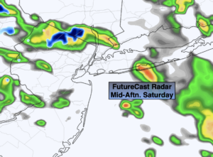
More clouds than sun. Scattered showers. Slight chance of a thunderstorm. Most of the day will be dry. Highs in the mid 50s. West winds at 8-15mph.
Tonight:
Evening scattered showers, otherwise skies will be partly cloudy. Lows in the mid 30s in the City, around freezing inland. West winds at 8-15mph.
Sunday:
Clouds, some sun. Isolated showers. Windy and cooler. Highs in the mid 40s.
Monday:
Mostly sunny, breezy and cold. Highs only in the 30s.
Tuesday:
Mostly sunny. Chilly. Highs only in the mid 40s.
Wednesday:
Mostly cloudy. Showers possible. Cool. Highs only in the upper 40s.