Synopsis:
As a cool front approaches this evening scattered showers and storms will move through. Some of the storms may become severe. The showers and scattered storms will move off the coast by toward midnight. Skies will become partly cloudy.
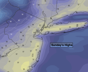
Spring officially arrives Sunday at 11:33am EDT. Our continuation of above average temperatures will greet the new season. A mix of sun and clouds is expected behind the cool front. Readings will be several degrees above the average high of 50º.
Next week will start off bright and mild with high pressure in control.
The next chance of showers will come Wednesday into Thursday morning with an approaching front.
Stay tuned.
Keep it here for a no hype, no nonsense forecast.
Catch me on The Fox Business Network from 6am-9am this weekend & on the Fox Weather Stream from 9am-Noon.
Tonight:
Scattered showers and storms early. Some of the storms maybe severe. Becoming partly cloudy. Lows around 50º in the City, the 40s elsewhere. West wind at 5mmph. .
Sunday:
Partly sunny. Highs in the mid to upper 50s. West to Northwest winds at 10-20mph.
Monday:
Partly sunny. Highs around 60º.
Tuesday:
Mostly sunny. Highs in the mid 50s.
Wednesday:
Mostly cloudy with showers likely by afternoon. Seasonable. Highs around 50º.
Thursday:
Morning showers. Afternoon sun. Highs around 60º.