Synopsis:
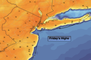
Today will feel like a day out of May. Morning fog and clouds will lift and the sun will then dominate. Highs will be around twenty degrees above the average high of 50º! It will be cooler at the coast an over parts of Long Island and CT.
Clouds will increase tonight. Mild readings are expected. Temperatures will be around the average high for the date for overnight lows.
On Saturday, a cool front will approach with on and off showers.
Spring officially arrives on Sunday, March 20th at 11:33am EDT. Our continuation of above average temperatures will greet the new season. A mix of sun and clouds is expected behind the cool front.
Next week will start off bright and mild with high pressure in control.
Stay tuned.
Keep it here for a no hype, no nonsense forecast.
Friday:
Morning clouds and fog giving way to mostly sunny skies. Warm. Highs around 70º. Cooler at the coast. West to Southwest winds at 5mph.
Tonight:
Increasing clouds. Lows around 50º. Light Southeast wind.
Saturday:
Mostly cloudy with scattered showers. Highs in the lower 60s.
Sunday:
Partly sunny. Highs in the mid to upper 50s.
Monday:
Mostly sunny. Highs around 60º.
Tuesday:
Mostly sunny. Highs in the mid 50s.