Synopsis:
It’ll be a Spring preview for this last week of Winter. Above average readings are expected through Saturday.
Bright & mild conditions are in the forecast as high pressure slips off the Southeast coast through Wednesday.
On Thursday, a weak low will move up the coast with scattered showers for St. Patrick’s Day . Friday will be warm with a Southwesterly flow taking hold.
On Saturday, a cool front will approach with the threat of showers.
Spring officially arrives on Sunday, March 20th.
Stay tuned.
Keep it here for a no hype, no nonsense forecast.
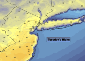
Tuesday:
Mostly sunny. Very mild. Highs in the lower 60s. Winds becoming South at 5mph.
Tonight:
Partly cloudy. Mild. Lows around 50º in urban areas, the upper 30s & 40s inland. Southwest to Northwest winds less than 5mph.
Wednesday:
Partly sunny. Mild. Highs in the mid 60s.
Thursday (St. Patrick’s Day):
Mostly cloudy. Showers likely. Highs in the mid 50s.
Friday:
Partly sunny. Warm. Highs in the mid 60s.
Saturday:
Mostly cloudy with scattered showers. Highs around 60º.