Synopsis:
Thursday will be bright but the wind will be busy adding a bit of a bite as cold high pressure works in from Canada. Readings will be steady and then fall into the 30s during the afternoon.
Tonight will be very cold with readings well below freezing under clear skies and diminishing winds.
Cool readings are expected for the rest of the week into the beginning of the weekend with the sun dominating.
High pressure will move off the coast and a front will approach from the West on Sunday. Temperatures will pop to Spring-time levels. Spotty showers are possible during the afternoon, but much of the time should be dry.
Monday will feature our continuation of warm conditions. Another area of low pressure will work up and to our West with another threat of spotty showers.
Keep it here for a no hype, no nonsense forecast.
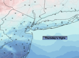
Thursday:
Mostly sunny. Breezy and Colder. High around 40º with readings falling into the 30s later in the day. Northwest winds at 15-25mph with higher gusts.
Tonight:
Clear and very cold. Lows around 20º in the City, 10º-20º inland. Northwest winds at 10-20mph and diminishing.
Friday:
Sunny. High in the mid to upper 30s.
Saturday:
Mostly sunny. High in the lower to mid 40s.
Sunday:
Mostly cloudy. Balmy. Spotty afternoon showers. High in the lower to mid 60s.
Monday:
Mostly cloudy. Balmy. Spotty afternoon showers. High in the lower to mid 60s.