Synopsis:
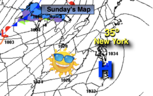
It’ll be a bright Sunday, but despite the sunshine readings will struggle to get above freezing. Winds will not be an issue as high pressure sits over the East coast.
Readings tonight will be much milder than recent nights as cold high pressure slips offshore.
On Presidents’ Day, a mild push will arrive as winds turn to the Southwest. Highs will be ten degrees above average under abundant sunshine.
Low pressure will head toward the region Tuesday. Thickening clouds and showers are expected by afternoon. It’ll will be mild.
Wednesday will greet us with another Spring preview as we’ll be in between systems. Cold air will remain well to the North.
Thursday should be dry but the next in a series of low pressure systems will throw clouds our way. It’ll be much cooler as the flow will turn out of Canada.
Stay tuned.
Sunday:
Sunny and chilly. Highs in the lower to mid 30s. West to Southwest winds at 8-12mph.
Tonight:
Clear. Lows around freezing in the City, the teens and 20s inland. Southwest winds at 5-10mph.
Monday:
Mostly sunny. Milder. High in the lower to mid 50s.
Tuesday:
Thickening clouds. Showers possible. Mild. High in the mid 50s.
Wednesday:
Sun and clouds. Warm. High around 60º.
Thursday:
Clouds and sun. Much cooler. High around 40º.