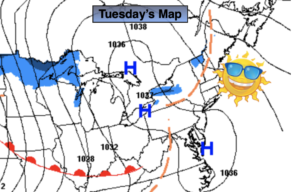
Synopsis:
Today, many regions will flirt with the freezing mark. Strong high pressure be over the region. Winds will be light.
It’ll be another cold night but it won’t be as bitter as recent nights.
High pressure will move offshore Wednesday. A return Southwesterly flow will cause readings to start their climb to more tolerable levels. Highs will be a few degrees above the average of 42º. By Thursday, a deep Southerly flow will result in Spring-like readings. Highs will approach 60º. Any showers should hold off until later Thursday evening as a significant front makes it’s approach.
Rain is likely Thursday night into early Friday morning as the front sweeps through. Readings on Friday will still be mild in the morning but temperatures will fall in the afternoon.
The beginning of the Presidents’ Day holiday weekend looks bright and tranquil with tolerable temperatures.
Stay tuned.
Tuesday:
Sunny. Highs in the lower 30s. Northwest to West winds at 5-10mph.
Tonight:
Mostly clear. Not as cold as recent nights. Lows in the upper 20sin the City, the teens and 20s inland. Southwest to South winds at 5mph.
Wednesday:
Mostly Sunny. Milder. Highs in the mid to upper 40s.
Thursday:
Mostly cloudy. Balmy. Showers possible later in the day. Highs around 60º.
Friday:
Early morning rain, otherwise mostly sunny. Highs in the lower 50s. Temperatures will fall during the afternoon.
Saturday:
Party sunny. Highs in the mid 40s.