Synopsis:
Happy Valentine’s Day!
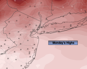
Today will be very cold with readings remaining in the 20s as Arctic high pressure dominates. The sun will dominate.
Tonight will be another frigid night. Some areas inland will approach 0º.
On Tuesday many areas should approach or crack freezing under sunny skies.
High pressure will move offshore by midweek. A return Southwesterly flow will cause readings once again to pop to Springtime levels. Any showers should hold off until later Thursday as a significant front makes it’s approach.
Rain is likely Thursday night into Friday morning as the front sweeps through. Readings on Friday will still be mild in the morning. Readings will later in the afternoon.
Stay tuned.
Today:
Mostly sunny, breezy and very cold. Highs in the upper 20s. Northwest winds at 15-25mph. Wind chills in the teens and lower 20s.
Tonight:
Clear and frigid. Lows in the upper teens in the City, 0º to 10º inland. Northwest winds at 5mph.
Tuesday:
Sunny. Highs in the lower to mid 30s.
Wednesday:
Mostly sunny. Milder. Highs in the upper 40s.
Thursday:
Mostly cloudy. Balmy. Showers possible later in the day. Highs around 60º.
Friday:
Morning rain. Afternoon sun. Highs in the lower 50s.