Synopsis:
The Arctic high will relinquish it’s grip across the region today. February’s debut will feature mainly sunny skies and seasonal temperatures for a change. The average high is 38º.
A mild Southwest flow will develop Wednesday and Thursday. Wednesday’s readings under a mix of sun and clouds will be several degrees above average. Snowmelt will continue. Thursday will be Spring-like with light rain developing later in the day as a front approaches from the West. Rain is likely Thursday night.
On Friday, the a low along the cold front will pass the area. Rain will possibly change over to wintry precipitation (especially inland) depending on how much cold air bleeds into the system. The potential is there for sleet, freezing rain and some snow. This is a few days away and if the warm air wins out it will be mainly rain.
No matter the outcome, Saturday will feature another bitter blast with readings below freezing. At least the sun will be shining!
Stay tuned.
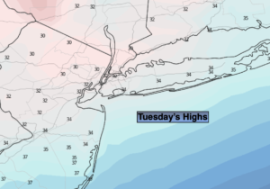
Tuesday:
Mostly sunny. Seasonal. Highs in the upper 30s. North to East winds at 5-10mph.
Tonight:
Partly cloudy.Not as cold as recent nights. Lows in the lower to mid 30s in the City, the teens and 20s inland. Light winds.
Wednesday:
Partly sunny. Milder. Highs in the mid 40s.
Thursday:
Mostly cloudy. Light rain likely later in the day. Spring-like. Highs in the upper 40s.
Friday:
Rain along the coast possibly changing to sleet or freezing rain. Possible freezing rain, sleet and snow inland.. Cooler. Highs near 40º with readings falling during the day.
Saturday:
Mostly sunny. Much colder. Highs in the upper 20s.