Synopsis:
Temperatures will crack freezing on Monday in urban areas and February’s debut will be seasonal. Both days will feature plenty of sun as high pressure moves off the coast.
A mild Southwest flow will develop Wednesday and Thursday. Wednesday’s readings under a mix of sun and clouds will be several degrees above average. Thursday will be Spring-like with scattered showers as a front approaches from the West.
On Friday the a low along the cold front will pass the area. Showers are likely. There’s a slim chance that if enough precipitation is behind the front when the colder air bleeds in that the precipitation may end as some wet snow or sleet.
Stay tuned.
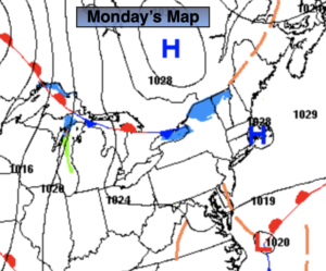
Monday:
Mostly sunny. Highs in the lower to mid 30s. East to Northeast winds at 5mph.
Tonight:
Partly cloudy. Lows in the upper 20s in the City, the single digits and teens inland. Light winds.
Tuesday:
Mostly sunny. Seasonal. Highs in the upper 30s.
Wednesday:
Partly sunny. Milder. Highs in the mid 40s.
Thursday:
Mostly cloudy. Scattered showers. Spring-like. Highs near 50º.
Friday:
Mostly cloudy. Early rain may end as a mix North and West. Cooler. Highs near 40º.