Synopsis:
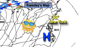
High pressure over the region on Tuesday will deliver abundant sunshine and below average temperatures.
Readings tonight will be much warmer than last night as high pressure moves offshore.
Temperatures will pop on Wednesday to several degrees above the average high of 40º. A Southwest wind around offshore high pressure will be responsible for our reprieve from the cold. A cool front will approach during the afternoon with the threat of a few showers.
Thursday will be seasonal as another front moves through with a mix of sun and clouds.
On Thursday night and Friday morning low pressure will be developing over the Southern Appalachians. This system will intensify and move rapidly off our coast by Friday morning. The potential is there for a period of snow Thursday night into Friday morning. As of this writing, the storm looks to be a quick hitter (6-8 hours) which should keep any snow amounts on the low side.
After the potential early morning snow on Friday, the sun will return and it’ll be blustery.
Behind this system bright but cold conditions are expected for Saturday as high pressure moves in from Canada.
Stay tuned..
Tuesday:
Sunny. Cold. Highs in the mid 30s. Northwest to Southwest winds at 5mph.
Tonight:
Clear early, becoming partly cloudy late. Much milder than last night in urban areas. Lows in the 30s in the City the 20s inland. Southwest wind at 5mph.
Wednesday:
Clouds and sun. Chance of a few showers. Milder. Highs in the mid 40s.
Thursday:
Mostly sunny. Seasonal. Highs in the lower 40s.
Friday:
Early snow possible, otherwise becoming sunny and windy. Highs in the 30s.
Saturday:
Sunny. Cold. Highs around freezing.